Hamburg Living Lab
5G to improve logistic processes automation in ports and mission critical services with continuous business & technical-related 5G system optimization.
Living Lab description
With around 10 million containers, the Port of Hamburg is ranked No.3 in Europe. Due to its special situation as a city port, several terminals for container handling are spread across different parts of the city, which makes an efficient hand-over and automation within the intermodal transport chain (port internal transfers) of great importance for Hamburg’s long-term competitiveness.
For the ITS World Congress, which took place in October 2021, Hamburg launched in 2019 a test field for automated driving to optimize the access of trucks to the port terminals. The test field is located in the heart of the city close to the ferry boat terminals (see Figure 1 and Figure 2). In 5G-Loginnov, T-Systems, Continental, SWARCO and tec4u build their highly innovative 5G use cases directly on top of this test track and link the 5G features, in especially Mobile Edge Computing, low latency communication (uRLLC) and advanced IOT including massive Machine Type Communication (mMTC), to I.T.S. functions implemented by the Hamburg traffic authorities. The Hamburg Port Authority (HPA) already connected traffic lights operated in the ferry port and cruise terminal area to guarantee a seamless traffic flow within the heart of Hamburg’s tourist zone near “Landungsbrücken” see Figure 2. The interaction between the logistics corridors connecting warehouses, motorways and shipping terminals with the busy road network inside the densely populated city centre, is the unique innovation highlight of the TAVF Hamburg test track.

Figure 1: Aerial view of Hamburg Port (Cruise Terminals)
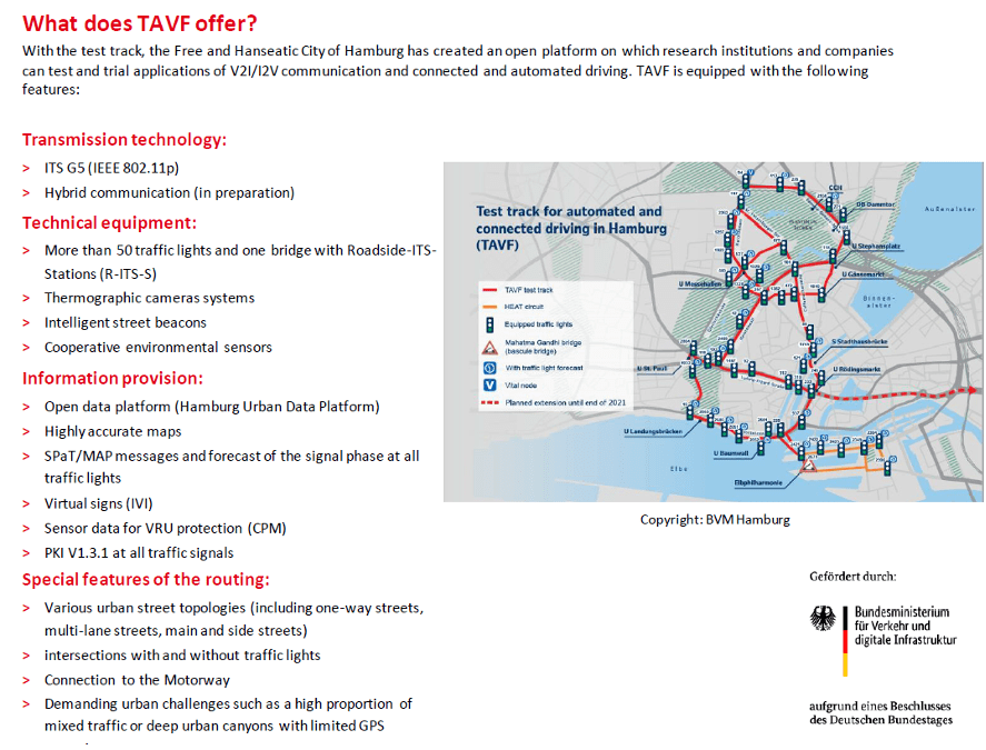
Figure 2: Test track for automated and connected driving in Hamburg used by the 5G-Loginnov Living Lab
5G Innovation
Hamburg Living Lab demonstrates the potential of leveraging positive environmental impact by using 5G in data exchange for traffic management in particular outside the port and the hinterland. It develops and implements a methodology to capture the effect of the traffic infrastructure on regional emissions, making them comparable (standardized) by quantifying such influences under defined TMS congestion and other relevant factors (driver profile, vehicle profile, loading, etc.).
The living lab Hamburg demonstrates 5G innovations for logistics in the Hinterland of the harbour of Hamburg by using the public 5G network operated by the Deutsche Telekom. This public 5G network covers the designated test field for “connected and automated driving” (TAVF) of the city centre of Hamburg. Within this environment, the LL Hamburg illustrates on one hand how new functionalities of 5G as MEC, precise positioning as uRLLC can improve the efficiency of logistic operations, but on the other hand, also proves that improved 5G network functionalities as mMTC and eMBB are essential for stable service operation.
Hereby, network slicing is one of the key aspects of 5G that will allow network and service operators to satisfy specific connectivity demands of specific use-cases. By this, it can be ensured that each use case will always have the required resources. The 5G-Loginnov Living Lab Hamburg will illustrate the use of two different virtualized and independent networks based on the available public 5G network. Each of the two slices will allow using the available network with the use-case specific required level of service quality, security, and reliability.
Figure 4 shows the existing set-up of TAVF and Telekom Mobile Edge Infrastructure implemented in Hamburg since 2021.
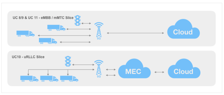
Figure 3: Network Slices LL – Hamburg
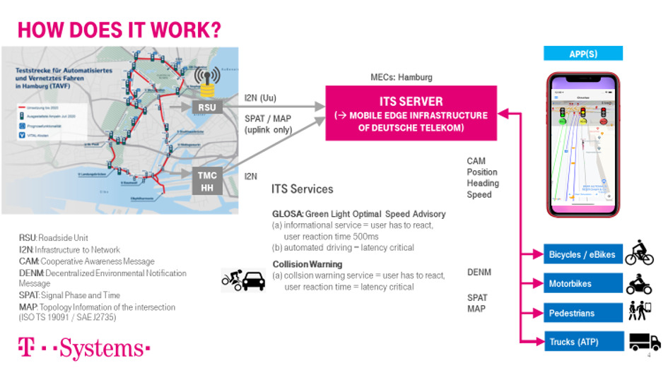
Figure 4: Technical Systems implemented and used in 5G-Loginnov – Hamburg
UC8/9: 5G-LOGINNOV Floating Truck and Emission Data (FTED)
For any traffic management measure by a dynamic traffic management system, it is essential to evaluate cause and effect of specific manoeuvres and resulting emission profile. However, a reliable evaluation based on existing telemetry and telematic systems within a dynamic environment is hardly possible. The best possible results and answers for those questions with all contributory causes can only be achieved if it is possible to include the influence of the specific infrastructure (e.g. junction area) including their characteristics and related base driving profile.
In view of the fact that even static infrastructure (e.g. fixed signposting and traffic routeing) depending on the volume of traffic and disturbance variable (e.g. weather, driving behaviour of others, dangerous situations, etc.) always provokes a dynamic driving behaviour regarding executing and location of a manoeuvre, the detailed evaluation is already a major challenge. The overall potential of emission reduction is mainly related to vehicle type and configuration (body, mass, power train, brakes, tyres, etc.), current vehicle conditions (e.g. maintenance level, load), route characteristics, TMS measures (static and dynamic), traffic flow, driver / driving profile (acceptance of TMS measures).
To synchronize TMS measures and traffic effectively it is necessary to analyse and describe the driving manoeuvres of commercial vehicles in such a detail that the influence of route, infrastructure, vehicle, use case / weight and driver (interaction with the vehicle to execute a specific manoeuvre) within a dynamic traffic environment could be isolated and assigned individually to the emission profile of the causer.
This will be achieved in 5G-LOGINNOV by the following measures:
- 5G real-time truck & emission data (telematics and telemetry sets of vehicle-based sensors, including CAN-Bus data) collected by LCMM (Low Carbon Mobility Management) and Entruck
- Increase of precision for the parameters of the applied energy equation used by LCMM and Entruck, e.g. tire pressure, RPM, engine efficiency and position
- Characterisation of infrastructure regarding wearing and emissions based on real vehicle data and behaviour, including an ongoing verification
- Real-time analysis of manoeuvres and direct provision of results in a specific format for use in other use cases or third parties
- Calibration of external services based on speed profiles and lower data resolution
UC10: 5G-LOGINNOV GLOSA & Automated Truck Platooning (GTP)
Green Light Optimized Speed Advisory (GLOSA) is an application where vehicles and traffic infrastructure communicate with each other in order to minimize capacity shortage across complex urban road networks (figure 5).
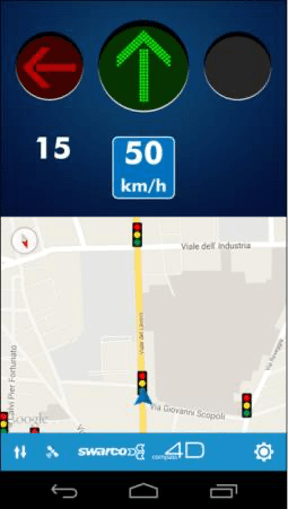
Figure 5: GLOSA application to facilitate communication between vehicles and traffic infrastructures
The Cost-Benefit-Analysis of real-world implementation could prove positive impact with regards to economic and environmental impact, especially in combination with Advanced Driver Assistance Systems (ADAS) or by conventional Automatic Cruise Control (ACC). The introduction of GLOSA functionality can generally be recommended from the economical point of view when taking major pollutants (NOx, CO, HC, PM) as well as traffic linked climate gas emissions, primarily CO2 into account.
Additionally, it is well-known that minimizing acceleration and braking incidents can save ca. 30% of fuel consumption and combustion engine related emissions, i.e. NOx. As found in several measurements by traffic researchers, NOx emissions show a rather extreme increase whenever Start-Stop engine ignition is applied and reliable GLOSA information would help to reduce these emissions. Trucks have the highest fuel consumption of road infrastructure using vehicles, including NOx and PM. Therefore, GLOSA will help to reduce emissions, i.e. by setting up Automated Truck Platoons along pre-defined Logistics Corridors
Whereas traditional GLOSA technology has a focus on implementing single-vehicle speed advise, 5G GLOSA for Automated Truck Platoons goes far beyond this concept as it enables green light optimized speed advisory for a platoon of trucks emitting the possible minimum of pollutants by taken into account real-time data of the vehicles driving within the platoon as well as green light and green wave optimized traffic signalling.
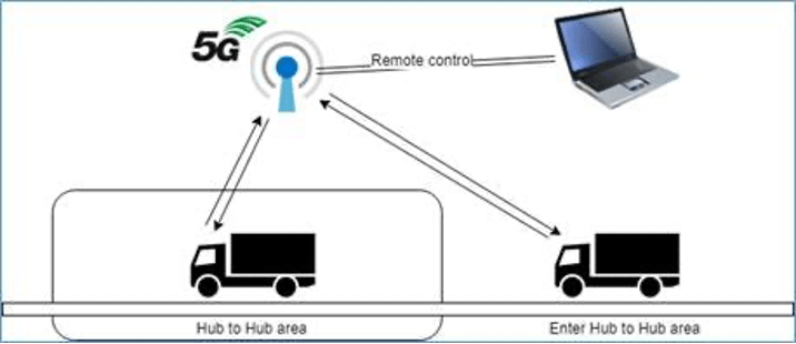
Figure 6: 5G GLOSA for Automated Truck Platoons
- Using 5G GLOSA in the context of Automated Truck Platoons
- Test by implementing logistics platoons along the logistics corridor of Use Case 3
Innovation by 5G linked to traffic control: precise positioning and D-GPS, MEC and eMBB
UC11: 5G-LOGINNOV dynamic control loop for environment sensitive traffic management actions (DCET)
Stop & Go incidents cause in any port ~30% fuel consumption more than smooth extra urban traffic meaning 30% more CO2 emissions! Additionally, Stop-&-Go increases NOx emissions due to the engine characteristics and inertia forces acting on the vehicle while accelerating to regular speed. In order to achieve these targets, it is planned to:
- 5G real-time truck & emission data (telematics and telemetry sets of vehicle-based sensors, including CAN-Bus data) collected by LCMM (Low Carbon Mobility Management) and Entruck
- define the logistics corridors in close cooperation with stakeholders from the port and logistics community in close cooperation with the environmental agencies and the traffic management authorities
- to exchange complex V2X information via 5G making use of the 5G inherent precise positioning as well as of the eMBB, URLLC, and mMTC functionalities of the mobile network to guarantee green light priority and speed advisory of a truck platoon in port-city’s automated test field
to showcase how 5G GLOSA can be applied in other logistics corridors decreasing air pollution, i.e. for NOx and CO2
An overview of the air quality detection sites of Hamburg port and the Air Quality Index across the logistics corridors feeding the container flow to the port terminals is indicated in Figure 7 and Figure 8.
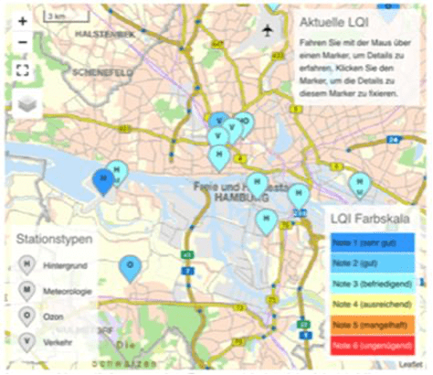
Figure 7: Air quality index across the logistics corridors
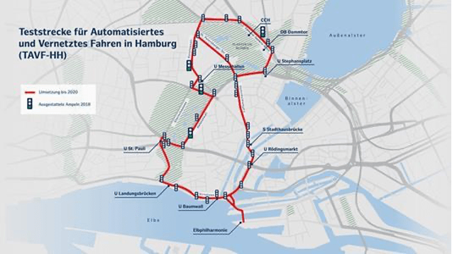
Figure 8: Air quality index along the main logistic feeders to the Port of Hamburg Living Lab

